Showing posts with label Sabina Shoal. Show all posts
Sunday, February 3, 2013
Philippine Spratly Islands, Malaysia and China
DO NOT FORGET SCARBOROUGH SHOAL... KEEP UP THE DRUM BEAT FOR SCARBOROUGH SHOAL AND FOR ALL PH ISLANDS IN THE SPRATLYS. PH TECHNICALLY 'OCCUPIES' 10 FEATURES comprising seven islands and three reefs in the Spratlys but 'militarily occupies' only 7 of the 10 features*...
BUT IF YOU THINK, ONLY CHINA IS STEALING OUR ISLANDS (Mischief Reef, Scarborough, Half Moon Shoal, Sabina Shoal), WELL, YOU ARE MISTAKEN!
MALAYSIA HAS STOLEN FROM PH TWO ISLANDS THAT TECHNICALLY BELONG TO THE KALAYAAN ISLAND GROUP while PH was not looking... They occupied Erica Reef (Gabriela Silang Reef) which is part of the Philippine Kalayaan Island Group attached to the Municipality of Kalayaan, District of Palawan as well as Investigator Shoal (Pawikan Reef). Both are well within the 200 nautical mile EEZ of the Philippines.
NOTE: In 1999, Malaysia occupied Gabriela Silang Reef (Erica Reef) and Pawikan Reef (Investigator Shoal), causing the Philippines to protest but nothing came out of it. (Incidentally, Vietnam has also stolen one our islands when PH troops were away partying... But that is another story.)
Not only has Malaysia illegally annexed Sabah, they now use Sabah to lay claims and to occupy other islets, reefs, shoals that they say are within Sabah's 200 nautical mile EEZ. They occupied Swallow Reef (Celerio for the Philippines), which they now call Layang-Layang, on the basis that it is within Sabah's EEZ and have been maintaining a Malaysia Navy offshore security post called Uniform Station on the reef.
*CLAIM & OCCUPATION
The Philippines is now left with the following "features" in the Spratly (Wiki):
Pagasa Island (Thitu Island)
Likas Island (West York Island)
Parola Island (Northeast Cay)
Lawak Island (Nanshan Island)
Kota Island (Loaita Island)
Patag Island (Flat Island)
Panata Island (Lankiam Cay)
Rizal Reef (Commodore Reef)
Balagtas Reef (Irving Reef)
Ayungin Reef (Second Thomas Reef)
But only 7 of them are militarily occupied (Wiki):
Occupied by the Philippines
Thitu Island · Pagasa Island
West York Island · Likas Island
Northeast Cay · Parola Island
Nanshan Island · Lawak Island
Loaita Island · Kota Island
Flat Island · Patag Island
Lankiam Cay · Panata Island
BEWARE OF YOUR BACKDOOR NEIGHBOURS!
Saturday, December 15, 2012
China's creeping invasion of Philippine EEZ: Mischief Reef, Sabina Shoal, Scarborough Shoal, what next?
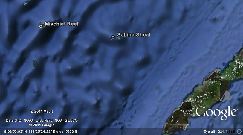
GOOGLED IMAGE OF 'STOLEN' MISCHIEF REEF AND SABINA SHOAL both well within the 200-nautical mile Philippine Exclusive Economic Zone (EEZ) and located exactly 130 miles (209 km) and 70 miles (113 km) away from Palawan respectively. In 1994, when the Philippine Navy was not looking, China invaded Mischief Reef and planted structures. The Philippines decided not to press for its recovery. China then took control of Sabina Shoal which was even nearer Palawan.
In 2012, China repeated their illegal exploits in Philippine EEZ by encircling Scarborough Shoal and declaring all of South China Sea (which overlaps our own West Philippine Sea) as theirs. What will be their "Sabina Shoal" this time? Will it be the Hermana Mayor island or the Hermana Menor Island which are found northwest off the coast of Zambales?
TIME ASIA REPORT ON CHINA'S ILLEGAL OCCUPATION OF MISCHIEF REEF AND SABINA SHOAL:
TIME Asia 030899
MISCHIEF REEF
September 14, 1999We must NOT ALLOW what happened to Mischief Reef and the succeeding occupation of Sabina Shoal (because we did not react with determination) to happen again. We must guard our other islands in the Spratlys, patrol West Philippine Sea relentlessly to show bit of presence. Navy and Coast Guard do not need to patrol with guns blazing. All they need IS TO PERFORM THEIR JOB.
After several passes the pilots turned back toward Palawan, but on the way they descended to check out another reef, the Sabina Shoal, which is even closer to the Philippines and on which Chinese marker buoys have been foundand blown upby the navy before. The Chinese have a wellrehearsed routine when laying claim to a new reef first they put down buoys, then they build concrete markers. Temporary wooden or bamboo shelters follow, and if they are still not challenged, the permanent military forts go up. The Philippines tries to blow up the buoys or the markers before China has time to build and occupy larger structures. We cant demolish the inhabited structures because we dont want war in the Spratlys, says presidential spokesman Jerry Barrican.
By not allowing our Coast Guard to patrol our territorial waters, i.e., Scarborough, Malacanang is sending a very bad signal to China, which will inevitably reflect very poorly on ALL, and we mean, ALL Pinoy citizens.
There is nothing to fear. PCG or PN patrolling our coast WILL NOT lead to war with China. In the first place, Pinas has no capability to enter into a war with China so there will be no war. If China becomes militarily violent against Pinas, they will be facing world condemnation.
Our vessels, however, do run the risk of being rammed, and worse, one of them sunk by China vessels. Should the President take risk of possibly (just possibly) sacrificing a govt ship with, perhaps, loss of lives? The answer is yes. If President Aquino is not prepared to do it, then he must formally abandon our claim and move on as in put the entire China stealing episode behind us.
By Anne de Bretagne
16 December 2012
Subscribe to:
Posts (Atom)