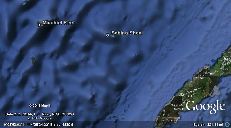
Folowing the imposition of a 15-nautical mile no entry zone around Scarborough Shoal which is located some 130 nautical miles from Zambales and is found well within the 200-nautical mile Exclusive Economic Zone (EEZ) of the Philippines, China launched an offensive yesterday to show virtual control of the Spratlys by sending one of its largest recorded fishing fleets to West Philippine Sea.
The waters in the Spratlys are known to be rich fishing grounds and are believed to contain a vast reservoir of oil and gas. But we are not confident that China is sending a Chinese fishing flotilla to the Spratlys merely to do a bit of fishing. We believe that some of these so-called 'fishing ships' include China PLA Navy elements which they have deployed "to plant" potential military communications or warfare paraphernalia which, in the future or in case of an armed conflict, will help serve as beachhead installations.
 |
| Mischief Reef stolen by China from PH in 1994 |
We must not to forget that in 1994, while the Philippines was not looking, China invaded Mischief Reef and installed 'sheds' which China leadership pretexted were to be used as shelter for their fishermen. Before the decade was over, China had transformed Mischief Reef into a sophisticated "listening" outpost and has turned it into a full-pledged military garrison.
Note that China has been aggressively pursuing a militarisation objective in the Spratlys and have been continuosly doing naval warfare exercises in the area that include underwater minelaying. It is a known principle that the country that controls the Spratlys and its waters will also control the sea lanes of communication (SLOCs) which could seriously imperil freedom of navigation for many countries that use those SLOCs.
It is imperative for the Philippine Navy and the Philippine Coast Guard to patrol the territorial waters of the Philippine Kalayaan Islands relentlessly to ensure that this latest naval maneuver by China will not go 'overboard' as in invade our inhabited Pag-Asa Island in the Spratlys and the other occupied PH Spratly territories.
The Philippine Navy and the Coast Guard must put it in their heads that their presence in those waters is a deterrence in itself.
The Philippine Navy and the Coast Guard must put it in their heads that their presence in those waters is a deterrence in itself.
Forewarned is forearmed!
~~ By Anne de Bretagne
For the Defenders of the Philippine Sabah and Spratly Claims
07 May 2013
INQUIRER NEWS REPORT: China sends large fleet to disputed Spratlys
BEIJING—China has sent one of its largest recorded fishing fleets to disputed islands in the West Philippine Sea (South China Sea), state-run media said on Tuesday, amid tensions over Beijing’s assertion of its claims in the region.
A flotilla including 30 fishing vessels set sail on Monday for the Spratly Islands, an archipelago disputed between China and other countries including the Philippines and Vietnam, the China Daily reported.
The fleet left China’s southern province of Hainan for a 40-day trip to the region, the report said, and includes two large transport and supply ships.
Chinese fishing boats regularly travel to the Spratlys, parts of which are also claimed by Taiwan and Brunei, but the fleet dispatched Monday was as large as one described as the biggest ever launched from the province when it set off last year.
China will make “every effort to guarantee the fleet’s safety,” the report quoted an official from the department of ocean and fisheries as saying.
China and neighboring countries have long used fishing fleets and maritime patrols to assert their territorial claims, and have upgraded their naval forces in recent years as tensions over claims in the West Philippine Sea have risen.
The Philippines and Vietnam have complained that China is becoming increasingly aggressive in its actions in the area — such as harassing fishermen — and also through bullying diplomatic tactics.
The waters around the Spratlys are rich in fishing resources and it is believed they could hold large oil and gas reserves.
OTHER NOTES:
What are the Spratlys?
According to Wikipedia, The Spratly Islands are a group of more than 750 reefs, islets, atolls, cays and islands in the South China Sea. The archipelago lies off the coasts of thePhilippines and Malaysia (Sabah), about one third of the way from there to southern Vietnam. They comprise less than four square kilometers of land area spread over more than 425,000 square kilometers of sea. The Spratlys are one of three archipelagos of the West Philippine Sea/South China Sea which comprise more than 30,000 islands and reefs...

A BIT OF KALAYAAN ISLANDS/PHILIPPINE SPRATLY ISLANDS HISTORY (from Wikipedia):
The Philippines sent troops to the Spratly group for the first time in 1968. It prioritized large islands such as Pagasa (Thitu) Island, Likas (West York) Island, Parola Island (Northeast Cay), Kota (Loaita) Island, Lawak (Nanshan) Island, and Pugad Island (Southwest Cay). Two small islands, Patag (Flat) Island and Panata Island (Lankiam Cay), were also occupied. Both are less than a hectare in size.
To further the claim of the Philippines on the island group, the late President Ferdinand Marcos, on June 11, 1978, formally annexed the Kalayaan Islands by virtue of Presidential Decree No.1596 to the Palawan.
 |
| December 2012 photo of China attack submarine being fitted for warfare |
PH TECHNICALLY 'OCCUPIES' 10 FEATURES comprising seven islands and three reefs in the Spratlys but 'militarily occupies' only 7 of the 10 features*...
BUT IF YOU THINK, ONLY CHINA IS STEALING OUR ISLANDS (Mischief Reef, Scarborough, Half Moon Shoal, Sabina Shoal), WELL, YOU ARE MISTAKEN!
MALAYSIA HAS STOLEN FROM PH TWO ISLANDS THAT TECHNICALLY BELONG TO THE KALAYAAN ISLAND GROUP while PH was not looking... They occupied Erica Reef (Gabriela Silang Reef) which is part of the Philippine Kalayaan Island Group attached to the Municipality of Kalayaan, District of Palawan as well as Investigator Shoal (Pawikan Reef). Both are well within the 200 nautical mile EEZ of the Philippines.
NOTE: In 1999, Malaysia occupied Gabriela Silang Reef (Erica Reef) and Pawikan Reef (Investigator Shoal), causing the Philippines to protest but nothing came out of it. (Incidentally, Vietnam has also stolen one our islands when PH troops were away partying... But that is another story.)
Not only has Malaysia illegally annexed Sabah, they now use Sabah to lay claims and to occupy other islets, reefs, shoals that they say are within Sabah's 200 nautical mile EEZ. They occupied Swallow Reef (Celerio for the Philippines), which they now call Layang-Layang, on the basis that it is within Sabah's EEZ and have been maintaining a Malaysia Navy offshore security post called Uniform Station on the reef.
*CLAIM & OCCUPATION
The Philippines is now left with the following "features" in the Spratly (Wiki):
Pagasa Island (Thitu Island)
Likas Island (West York Island)
Parola Island (Northeast Cay)
Lawak Island (Nanshan Island)
Kota Island (Loaita Island)
Patag Island (Flat Island)
Panata Island (Lankiam Cay)
Rizal Reef (Commodore Reef)
Balagtas Reef (Irving Reef)
Ayungin Reef (Second Thomas Reef)
But only 7 of them are militarily occupied (Wiki):
Occupied by the Philippines
Thitu Island · Pagasa Island
West York Island · Likas Island
Northeast Cay · Parola Island
Nanshan Island · Lawak Island
Loaita Island · Kota Island
Flat Island · Patag Island
Lankiam Cay · Panata Island
BEWARE OF YOUR BACKDOOR NEIGHBOURS!

A BETTER ILLUSTRATION OF THE "FIRST AND SECOND ISLAND CHAINS" WHICH ARE THE STRATEGIC FOCUS OF THE CHINA PLA NAVY's 'ACTIVE COASTAL DEFENCE'.

This is why we will be seeing more of China PLA naval maneuvers from the Pacific Ocean into the South China Sea/West Philippine Sea -- just as we will be seeing more and more of US naval fleet maneuvers from the Pacific Ocean and the West PH Seas too! These "First and Second Island Chains" routes will be become the biggest naval "playground" in the world.
More and more, China will be strengthening their capability to obstruct those waters in the event of a war with the United States and they will do it by constantly doing maneuvers through those "ISLAND CHAINS". If you noticed, yesterday, China PLA Navy led by missile destroyer Qingdao triumphantly announced that their fleet that was deployed for patrol and other exercises had passed the "First Island Chain."
The United States knows that the 'First Island Chain' and the 'Second Island Chain' will be crucial in its strategy decision making process. In fact, the 'forecast' is that in "another 10-15 years, America’s qualitative military advantage will be eroded to the point that a conflict over Taiwan would jeopardize several large ships and aircraft carriers."
~~ Admin AdB, Defenders of the Philippine Sabah & Spratly Claims
RELATED POSTS:
- China pirates more of PH EEZ; imposes a 15-nautical mile no entry zone around Scarborough Shoal
- Philippines must not allow China to creep invade the Spratlys just like they did to Mischief Reef
- Mischief Reef and then Scarborough Shoal: "Never again?"
- The importance of the Spratlys and why it may be a "flash point" if China insists on blocking passage
- Cause of the Philippines-China stand off in Scarborough
- How can the Philippines reverse its Scarborough tactical blunder?
- China's Act of Piracy: Philippines must continue patrolling its Exclusive Economic Zone
- United Nation Convention on the Law of the Sea (UNCLOS), West Philippine Sea and Scarborough Shoal
- China and Malaysia have hijacked PH territories in West Philippine Sea
- China PLA Navy's 'active coastal defence': First and second island chains
- China's ultimate weapons of mass destructions will be their inter-continental ballistic missiles (ICBMs)
- China's minelaying technology